Natural Ventilation
Mapping of Wind Environment using GIS (Urban Scale)
GIS-based Surface Roughness Evaluation to Improve the Wind Environment
Urban environment has been changed and deteriorated, due to rapid urbanisation, as well as other factors including a lack of implementation of environmental information and knowledge in the urban planning practice. Therefore, there is a need to develop a systematic and user-friendly method for city planners and policy-makers to make scientific and evidence-based decisions in order to address urban environmental issues.
In this research, a high-resolution frontal area density (FAD) map that evaluates urban permeability was produced using an empirical model, which takes into account the heterogeneous urban morphology and local wind availability. Using the MM5/CALMET model simulated wind data , the FAD map of three urban zones were calculated: podium (0–15 m), building (15–60 m), and urban canopy (0–60 m).
Wind tunnel test data at Hong Kong was used to correlate the FAD understanding of the three zones with pedestrian-level wind environment. Linear regression analysis indicated that a lower urban podium zone yielded the best correlation with the experimental data, and 200 × 200 m was the reasonable resolution for the FAD map.
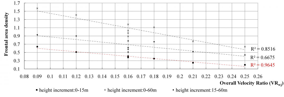
Figure. Validation by wind tunnel data.
This study further established that the simpler two-dimensional ground coverage ratio (GCR) that is readily available in the planning circle can be used to predict the area’s average pedestrian level urban ventilation performance of the city. Working with their in-house GIS team using available data, the GCR will provide the planners a way to understand the urban ventilation of the city for decisions related to air paths, urban permeability and site porosity.
This method to identify existing/potential air paths has been applied at Hong Kong, Macau, Wuhan, and other cities.
Outputs:
- A simplified method in GIS was introduced to evaluate urban permeability;
- Urban permeability was used to detect air paths for urban natural ventilation;
- Implementation of modelling results was interwoven into urban planning stages.
Publications:
- Yuan C, Ren C, and Ng E, 2014, GIS-based surface roughness evaluation in the urban planning system to improve the wind environment — A study in Wuhan, China, Urban Climate. 10, pp. 585– 593.
- Ng E, Yuan C, Chen L, Ren C, Fung JCH, 2011, Improving the wind environment in high-density cities by understanding urban morphology and surface roughness: A study in Hong Kong, Landscape and Urban Planning. 101 (1), pp. 59-74.
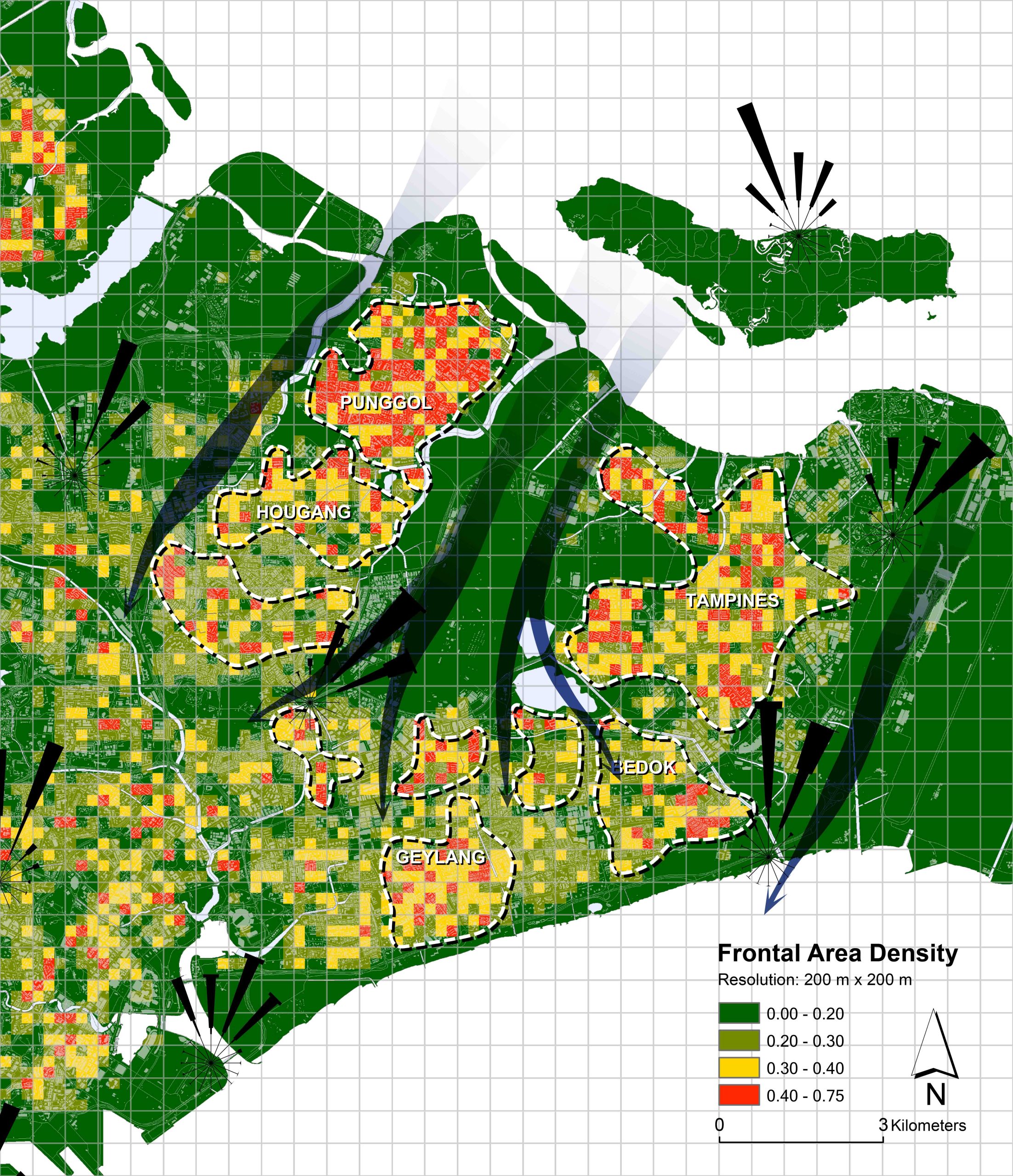
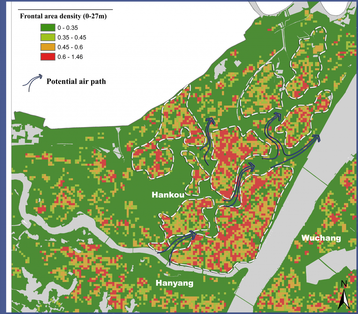 Figure. Air path I at Wuhan, China.

Figure Air path II at Wuhan, China.