Architecting resilient, future-proof cities
Follow CDE
PDF Download

NUS CDE researchers design a multi-scale, climate-sensitive framework to support urban design decision-making.
While urban centres have become the engine of national and global economic growth, generating over 80% of global GDP and lifting millions out of poverty, this shift is no bed of roses. The speed and scale of urbanisation tugs with it unprecedented challenges, from increased prevalence of infectious diseases to substantial changes in land use to escalating urban heat risk.
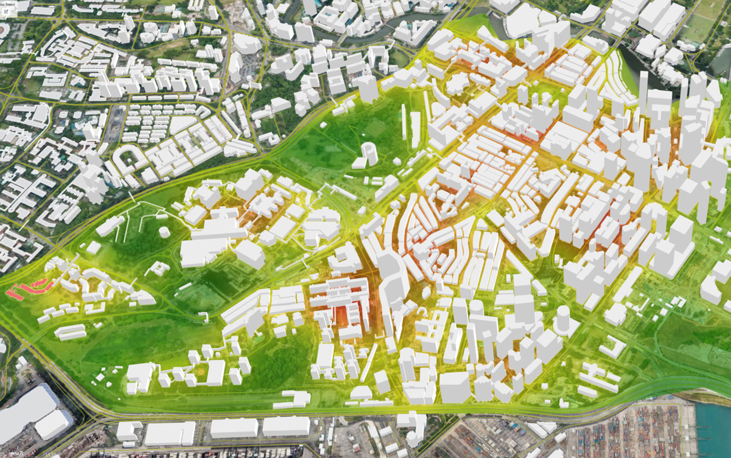
Perhaps one of the most recognisable hallmarks of densely populated cities is the urban heat island (UHI) effect. Travel from Bishan Park to downtown Singapore, for instance, and you may quite literally notice a tangible change in the atmosphere. On top of the warming already caused by climate change, the UHI effect intensifies urban temperatures, posing significant risks to human comfort, health and even economics.
Associate Professor Yuan Chao from the Department of Architecture (DOA) and NUS Cities at the College of Design and Engineering, along with Zhang Liqing, a PhD student from the same department, have developed a framework for climate-sensitive urban planning, taking Singapore as a focal case study.
Through a three-pronged approach — assessing UHI, wind and design implications — the researchers, who are affiliated with the Urban Climate Design Lab, aimed to weave climate considerations into urban planning to mitigate the UHI effect. This could help urban planners and governments alike make more informed decisions that balance both the local climate and urban development needs.
The study was published in Urban Climate on 28 February 2023.
Popular hotspots
The way cities are structure — with their concrete skyscrapers, extensive asphalt roads and sprawling vehicles — inherently amplifies and retains heat that is supposed to be dispersed at night. This leads to the UHI effect, where pockets of land in urbanised areas are several degrees warmer than the surrounding, suburban areas.
The implications of even a slight temperature rise are far from trivial, as it can pose substantial risks to human health, contributing to chronic illness and even death. Various conditions such as heat exhaustion, kidney damage and even cardiovascular diseases are exacerbated. For instance, one study in the Catalonia region of Spain reported a 19% increase in daily mortality following three consecutive days of intense heat.
“Optimising urban configurations is critical in the design and planning of cities,” says Assoc Prof Yuan. “Though the benefits may not be immediate, careful planning helps governments to reap benefits in the long run, creating sustainable and resilient living environments fit for the future.”
Future-proofing urban landscapes
The study’s first step involved assessing UHI intensity to locate urban hotspots. Utilising a Geographic Information System (GIS)-based digital climate platform, they mapped areas in the city-state experiencing higher temperatures compared to the rural area, Pulau Ubin. This enabled them to pinpoint specific areas that are most affected — notably Chinatown and some eastern areas, where the air temperature is three to five degrees higher.
“Employing accessible tools such as GIS-based digital platforms enable urban planners to conduct environmental assessments and identify the unique challenges specific to their cities,” explains Assoc Prof Yuan.
Natural wind was explored in the next step. By analysing the impact of buildings, terrain and trees on urban wind, potential air paths could be discerned to more efficiently harness natural ventilation to improve outdoor thermal comfort and air quality in urban areas. This highlighted how natural processes could be part of the solution too.
With these insights, the researchers formulated strategies that incorporate climate considerations into urban planning. These strategies encompass various elements, from the specific design of buildings to the integration of green-blue spaces, as well as how these components are spatially laid out within the urban fabric.
A key principle in the framework is the integration of multi-spatial scale analysis, bridging insights from large-scale urban studies to guide smaller, localised design decisions. This approach ensures that neighbourhood-level planning is cognisant of broader urban trends. “It’s about ensuring that every local project fits well within the broader urban climate system — one that is more efficient and unified,” says Assoc Prof Yuan.
Looking ahead, researchers will explore the balance between social science and technology for climate sustainability and resilience, considering socioeconomic impacts and acceptability across various demographic groups at the individual, household and community levels. Assoc Prof Yuan adds, “This is crucial in developing environments that are sustainable and resilient to climate change while enhancing the liveability of cities in the long term.”
Related
Yuan Chao ▏Associate Professor, Department of Architecture ▏LinkedIn Profile
Related Departments
Read More
View Our Publications ▏Back to Forging New Frontiers - April 2024 Issue
If you are interested to connect with us, email us at cdenews@nus.edu.sg


