

Integrated Coastal-Inland Flood Model for Climate Change
The purposes of this project are to develop an integrated inland-coastal flooding model integrating physical processes of storm surge-tide, wave runup, and rainfall induced overland flows; to review and collect essential bathymetry and topography data, and develop central database and data management system to improve understanding of the changing coastal environment in Singapore, to conduct research on coastal hydrodynamics in Singapore water, and develop additional physics-based modules to complement the integrated coastal flooding models, and to develop training materials and education programs for PUB staff on coastal and inland flood modelling.
The project comprises five main tasks.
Task 1: Improving existing surge-tide and wave model packages for strategic flood risk assessment
Under this task a storm surge-tide and wave model package will be developed and validated for calculating the sea water level anomalies under different weather events in South China Sea and in Singapore water. The model package will be used to estimate the sea water level anomalies under the future climate conditions in Singapore.
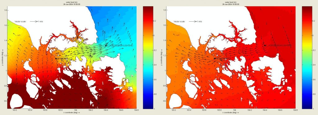
Figure 1. Sea water level (m; in colour) and current velocity (m/s; arrows) in Singapore water.
Task 2: Bathymetry/topography surveys and data management
Under this task we will work closely with PUB staff and provide PUB with the necessary inputs for the field surveys to collect bathymetric and topographical data, which are essential for modelling surge-tides, waves, and coastal flooding in Singapore. These new data sets will be added to the NUS developed geospatial data management system, which will smoothly integrate spatial datasets with the required models indicated in Task 1 and Task 3. This task will contribute to a national database of surveyed data accessible by all government agencies.
Task 3: Development of integrated coastal-inland models
The task plans to develop 1) an integrated coastal-inland model with a rapid flood solver system, 2) and the software and tools to support integrated modelling. The coastal-inland model will incorporate the sub-grid computing, semi-implicit analysis, and the use of GPUs for its computations to produce a state-of-the-art 2D (overland flows) -1D (canals/drains/rivers) integrated model with fast solver capabilities. The model calibration, validation and scenario simulations will be carried out to support PUB’s climate adaptation planning.
Task 4: Enhancement of integrated coastal-inland model system
In this task several physical coastal processes, relevant in Singapore water, will be investigated for their impacts on coastal infrastructures and coastal flooding. Accordingly, computational modules will be developed for each sub-project. These modules can be used as standalone computational tools or can be implemented in the integrated coastal flooding model package. Four topics have been identified as follows: 1) Developing a combined phase-resolving wind wave and storm surge model for coastal flooding; 2) Modelling wave-structure-foundation interaction under wind loading; 3) Modelling flow-vegetation interaction; 4) Modelling nearshore sediment transport.
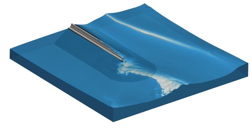
Figure 2. Wave diffraction by a breakwater
Task 5: Training and capability building
To ensure that PUB officers will be intimately familiar with model development process and to build up PUB in-house capability of executing the models as well as the GIS processes in the database, PUB officers will be embedded in the project throughout the model development. To ensure that the attached PUB officers have a core insight into the framework and system, NUS will provide specialised training and short courses.
For more details, please contact:
Distinguished Prof Philip Li-Fan Liu
Email: philip.liu@nus.edu.sg